
By way of introduction, I’m a fairly new Z4 owner having purchased a 2006 3.0i a month ago. It’s a replacement for my beloved BMW R1200GS motorcycle, which I can no longer ride due to medical reasons. I thoroughly enjoy touring back roads, looking for scenic spots and/or places of historical interest to enjoy, photograph, and write about. I’ve owned a lot of sports cars over the years, and I’m very impressed so far with the Z4. And I can think of it as a motorcycle with training wheels and a roll cage…
For my inaugural tour in the Z4, I turned to a book by Dale Coyner called Motorcycle Journeys through the Appalachians, Second Edition, and selected his “Pennsylvania Heartland” tour. Dale does an excellent job of finding and describing scenic routes with interesting things to see and do. This trip was no exception.
I left my home in Catonsville, MD in a light rain and drove to Gettysburg to begin the tour. Once on the official tour, I immediately put the top down, despite the occasional sprinkles–after all, I couldn’t wimp out all of the time. Following Dale’s route, I proceeded west along Robert E. Lee’s retreat path following the battle and soon ended up on South Mountain Road. While it’s tempting to call this road the highlight of the trip, in fairness I can’t–there were lots of highlights. As always, I kept an eye out for interesting old houses, such as the following:

The dilapidated house reminded me a lot of my West Virginia tours. But right around the bend, Pennsylvania revealed its high-class heritage with this mammoth abandoned building, lurking behind a narrow strip of forest. Having no idea what it had been, I decided to investigate.

Soon enough, I found the main entrance, drove on in, and looked around. Subsequently, a little Internet research revealed that this was unit 2 of the South Mountain Sanatorium (now known as the South Mountain Restoration Center). The sanitarium dates back as far as about 1901, although the abandoned building was built in 1938. It was originally a “preventorium” for children (a scary concept for sure) and later served as a tuberculosis hospital, among other things, before closing in 1985. Ironically, this impressive view was actually the back of the building; the front side, which I didn’t trespass far enough to discover, is even more imposing. As it happens, the 7-story unit 1 of the Restoration Center (seen here in the background) was built at the same time but is still being used today, as a nursing home. The Center also includes a home for repeat juvenile offenders. But it was a pleasant surprise to find such a stately group of buildings in the middle of nowhere in Pennsylvania. More info on the history of this place is available at South Mountain Restoration Center.

Near the entrance to Caledonia State Park, I passed by this attractive–though apparently man-made–waterfall.

Not much farther on, I located the original Chambersburg Reservoir, constructed in 1933 and holding almost 400 million gallons of water in its 52′ depth and 53 acre area. Or at least it did. Now there’s only a narrow stream flowing through the valley. Anyone know what happened?

I made a quick pass through Pine Grove Furnace State Park, having been there previously on the GS. This is the iron master’s mansion, which is now a youth hostel.

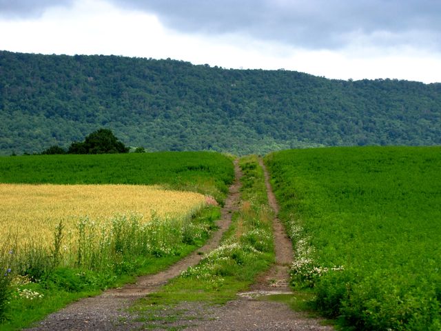
So far, my 4-wheeled motorcycle substitute was working just fine. Fun to drive, easy to turn around and backtrack for pictures, strong performance, etc. When I passed this road, however, I longed for the GS so that I could find out what lay just over the horizon…
Before long I arrived in the town of Landisburg. It had many interesting old houses–and in the case of this one, I had to wonder whether the wiring inside was as chaotic as the wiring outside…

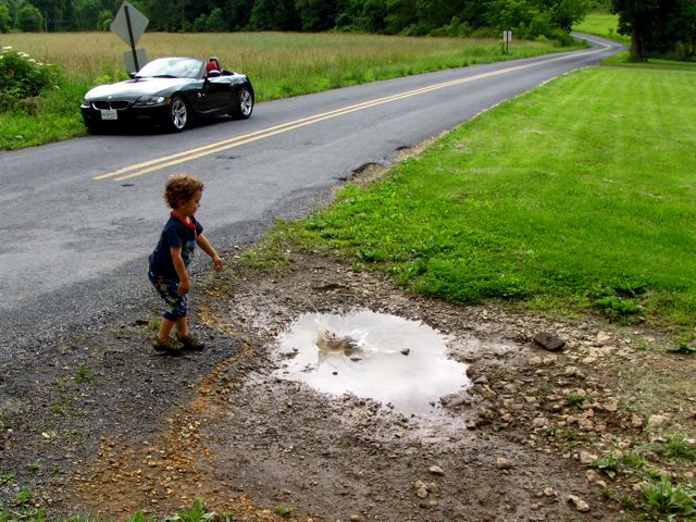
Just outside of Landisburg, following Dale Coyner’s directions, I found Rice’s Bridge at the confluence of Sherman and Montour Creeks. A nearby resident told me that it had been restored very recently–and promptly damaged by floods resulting from the prior week’s heavy rains (see damage to lower part of the bridge’s side).

The nearby resident’s son decided to try his hand at creating a flood in a puddle left over from the morning’s rain. Judging by the splash, I’d say he was successful.
Near Loysville, I encountered this one-time stately mansion, now in a state of significant disrepair. I couldn’t find much information about this place, except that it might have been a retirement home. I fervently hope that the pick-up trucks are there as part of a restoration effort–as opposed to an impending demolition.

Good ol’ Dale led me right to Adair’s Bridge many miles upstream on Sherman’s Creek. Pennsylvania does a nice job of taking good care of its covered bridges, I must say. Nearly every one I saw showed fresh paint and solid wood.


The many rural farms were not so lucky. Even when being actively worked, as this one was, many of them had a best-years-behind-us atmosphere.

There were many more covered bridges in this area, including the Bistline Bridge…

…and Enslow’s Bridge, in its unrestored glory. For reasons that weren’t clear, there was a very nice ford immediately next to the bridge. I might have been tempted with the GS, but not with a roadster featuring less than 6″ of ground clearance…

After tracking down all these bridges, it was well past lunch time. I eagerly looked forward to the town of Blain, where I was sure there would be a restaurant. What I found was one of the sleepiest little towns ever, full of intriguing houses but not a restaurant (or gas station) in sight. In fact, it was the kind of place that you could stand in the middle of the road to take pictures (and not be in any hurry, either). Looking more carefully, however, I found the Blain Hotel & Restaurant, which looked rather like a closed carry-out beer place. But it proved to be an open, quite decent little restaurant. A ham and cheese sub later, I was back on the road in search of Boundless Adventure and more Cool Stuff.


It had long since stopped raining, but the sky was still somewhat threatening. All of which made for the occasional scenic farm picture…

…and the occasional sight of a full-bore Army tank, with its main barrel pointed right toward said scenic farm. There’s probably a story here.

Back in 2008, my GS was running on fumes, showing 15 miles left on its fuel computer, and I barely made it into Spring Run to buy gas. Ironically, the warning light on my Z4 had been on for some time, the computer showed 15 miles left–and I had 7 miles to go to reach Spring Run! The sole gas station was open (again), and I happily filled up and pressed on toward Shade Gap and Orbisonia. On the way, I encountered St. Mary’s Bridge (my favorite of the trip and the last remaining covered bridge in Huntingdon County) plus the picturesque St. Mary’s Church in the background. The bridge over Shade Creek was built in 1894 (which predates even me) and featured open sides.

Orbisonia, PA is home to the East Broad Top narrow-gauge railroad. The station was easy to locate…

…but the rest of the depot looked pretty deserted.


The roundhouse looked in good (if rickety) working order, however, and seemed to have a supply of rolling stock.

Sure enough, before long a steam-powered locomotive arrived with a complete set of passenger cars. Stopping at the station, it picked up a load of sightseers and off it went, trailed by a thick cloud of coal smoke. Environmentally friendly it’s not, but it made a great sight.

This little vintage RR speeder was arguably the cutest thing I saw on the entire trip.

By now, the clouds were largely gone, the sun was out in full force, and it had turned into a beautiful day. I even began to see some motorcyclists on the road. Up to this point, I’d seen more horseback riders (and for that matter, red foxes) than bikers, let alone BMW roadsters. So which looks better, green fields, with blue sky, and a farm in the distance–or all of the above with a BMW Z4 in the foreground?


The nearly nonexistent town of Burnt Cabins proved to be worth the visit. It got its name in the 1740s because a number of settlers had built cabins on Indian land, prompting the Governor of Pennsylvania to order them burned (the cabins, not the settlers or Indians). There wasn’t any sign of these cabins, but a grist mill was still in evidence, along with a greater-than-average number of abandoned homes and farms. (Note the apparently abandoned vehicles that accompany the abandoned stone house that is quickly becoming lost in the trees.)


On the way to Mercersburg, I discovered the James Buchanan Birthplace State Park, commemorating (naturally) the birthplace of the country’s 15th President. It featured a stone monument and various historical signboards about this President. Well worth a visit and free, to boot.

Contrary to appearances thus far, not all of the houses I encountered in rural Pennsylvania were falling down or abandoned. These two examples, in Cove Gap and Waynesboro, respectively, were shining examples of places that would be fun to move into tomorrow:


I concluded the trip by traveling through Emmitsburg and Taneytown, MD, both scenes of my misspent youth. All told, I spent 11 hours and 330 miles trying out my motorcycle replacement. I concluded that the Z4 does just fine (naturally), and I thoroughly enjoyed getting back out on the road and exploring new places again. It was a good reminder of the wealth of scenic, historic, and interesting places that are within a stone’s throw of Baltimore and Washington. And anywhere that stone lands, there’s a high probability of finding beauty; all we have to do is look.

Rick F.
Leave a Reply